
 The Gap on the Map
Nathan Bailey wrote in 1731 that the River Mole is so named because “like a Mole, it forces its passage underground” [1].
This underground passage is shown on John Senex’s 1729 map of Surrey (see right). There is a gap shown in the river by Mickleham, as the river travels north alongside Box Hill towards Leatherhead. But was it really like that?
Daniel Defoe’s Observations
The novelist Daniel Defoe, who lived for a while in Dorking, was critical of these maps. In his travel book published in the 1720s [3], he spends a lot of time on the topic, saying that the maps were made by those who had never visited the place, and he confirms that the river ran ‘sharp and broad’ above ground by Mickleham:
“…nor did I ever know it dry in the dryest summer in that place, tho’ I liv’d in the neighbourhood several years: On the contrary I have known it so deep, that waggons and carriages have not dar’d to go thro’; but never knew it, I say, dry in the greatest time of drought.
However, he describes how the water flow is reduced by what he calls swallows, little channels which take the water away:
“…beginning, I say, where the river comes close to the foot of the precipice of Box-Hill, call’d the Stomacher, the waters sink insensibly away, and in some places are to be seen (and I have seen them) little chanels which go out on the sides of the river, where the water in a stream not so big as would fill a pipe of a quarter of an inch diameter, trills away out of the river, and sinks insensibly into the ground.
In this manner it goes away, lessening the stream for above a mile, near two, and these they call the Swallows; and the whole ground on the bank of the river, where it is flat and low, is full of these subterraneous passages; so that if on any sudden rain the river swells over the banks, it is observed not to go back into the chanel again when the flood abates, but to sink away into the earth in the meadows, where it spreads.
A Modern View
Wikipedia has a nice article on the Mole’s swallow holes:
“Between Dorking and Leatherhead the Mole cuts a steep-sided valley through the North Downs, creating a 170-metre-high (560 ft) river cliff on the western flank of Box Hill. The bedrock is permeable chalk and the water table lies permanently below the level of the riverbed, allowing water to drain out of the river through swallow holes in the bed and banks. The amount of water lost from the river is significant and in very hot summers the channel can become dry between Mickleham and Thorncroft Manor; this was recorded most recently in 1949 [see below] and 1976. At Leatherhead, the river leaves the chalk and flows across impermeable London Clay. At this point that the water table rises enough for the water to flow back into the main river channel.
In a survey in 1958, the geologist C.C. Fagg identified 25 active swallow holes between Dorking and Mickleham; most were only a few centimetres in diameter and were located in the vertical banks of the river below the water line. Most holes were difficult to observe in times of normal or heavy flow and were susceptible to silting up as new holes were continually being formed. A few much larger swallow holes were also observed separated from the main river by a channel of about a metre. About six of these larger swallow holes were found to the west of the Burford Bridge Hotel, along the course of the A24 Mickleham Bypass during its construction in 1936. Initially the surveyors tried to fill the holes with rubble to prevent the foundations of the new road subsiding. However this proved to be impractical and they were instead covered by concrete domes, up to 18 m in diameter, each fully supported by the surrounding chalk and provided with a manhole and access shaft to allow periodic inspection.
The water removed from the swallow holes also feeds the springs in Fetcham Mill Pond: In still conditions the resulting underwater spring can be seen emerging from the pond bed as a small “chalk volcano”. [4]
The 1949 Dry Patch
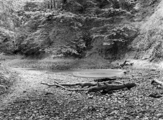
1949 picture of Swallow-hole in bed of River Mole
Photo credit J Rhodes “Photograph of swallow-hole in bed of River Mole”.
Geoscenic Digital Assets. British Geological Survey
The description of the photograph runs:
The photograph is of Ham Bank, Mickleham looking South (upstream). A number of swallow-holes are present in the bed of the River Mole, between Dorking and Leatherhead, many of which were exposed to view during the dry summer of 1949. The surface flow of the river gradually lessened downstream from Dorking due to loss in swallows, and the final remnant about 1 million gallons a day disappeared down a single swallow at Ham Bank; beyond the stream bed was dry.
The 2011 Mystery
In September 2011, the Leatherhead Advertiser ran an article on the Mole running dry: Mystery of river that vanished into thin air. The picture below shows the sorry state of the river. Apparently this occurred a couple of times, but each time the water was restored within 24 hours. The cause is uncertain, and although swallow holes might be to blame, other possible causes are also considered.
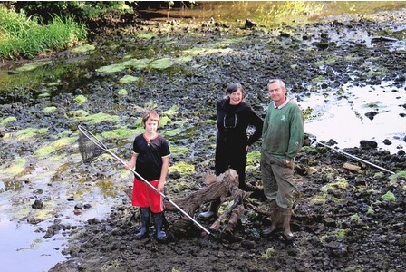
Picture credit: Leatherhead Advertiser
A second article a few months later suggests that the problem may have been caused by a hydropower scheme at Betchworth Estate, although the estate manager disagrees. The Environment Agency investigations continue…
Notes:
[1] An Universal Etymological English Dictionary, N. Bailey, 1731. eBook here.
[2] Map source: http://gallica.bnf.fr/ark:/12148/btv1b59670259/f1.zoom
[3] Daniel Defoe’s three volume travel book, Tour Through the Whole Island of Great Britain published between 1724 and 1727, Letter 2, Part 3: Hampshire and Surrey. eBook here.
[4] Geomorphology of the River Mole, from the Mole Valley Geology Society. There is also a map of the swallow holes in this reference.

This appears to be happening right now!
Wow – really? Which stretch of the river?
Very interesting. I’ve lived in Surrey all my life and this is all new to me. Looking forward to exploring this area when we next get a drought.
Just been to young street and the river mole is semi dried up. But go further up to the stepping stones and the water is flowing quite freely. Go down to burford bridge and the water is almost stagnated with very little flow. I think the last time the river dried up like this was 1976…when I was one!
It is amazing to see the dry river at Young Street and in small pools downstream towards Thorncroft where it starts to flow again, the wiki site on the river Mole confirms that in modern times, treated water is added to the river so it is hard to spot the ‘Swallows’ as in the past.